From 2016 – 2017, I was involved in a project to excavate a settler burial ground in Foxtrap, Newfoundland. The excavation was run by Dr. Vaughan Grimes and Maria Lear of the Archaeology Department at Memorial University of Newfoundland, and is under an active archaeological permit through the Provincial Archaeology Office (PAO) of the Government of Newfoundland and Labrador throughout post-excavation analysis. A handful of graduate students, including myself, made up the rest of the field crew.
Based on local knowledge and the PAO investigation of the site in 2006, we were already aware that there was likely a burial ground at this location, based on the several erect and laying markers and fragments of gravestone with inscribed text. While no single record appears to exist for who was buried at this site, and it only had one gravestone with inscriptions on it, the identities of most of the individuals interred there will likely remain a mystery (and that one gravestone was broken and out of situ so we have no idea whose grave it belongs to). Plans are already afoot to re-inter the remains nearby once they have been cleaned and studied.
I am honoured to have been part of the team exhuming this site, as it was the first full historical settler burial ground to be excavated in the province, and so much about early populations could (and will) be learned from those who were buried there.
My MA research at Ferryland was centered around the identification of grave shafts and other aspects of burials using different techniques such as remote-sensing & evidence in the sub-surface of disturbances, and so being part of this project was an opportunity for me to see just how grave shafts actually looked in Newfoundland after over 100 years or more. This turned out to be an extra-important learning opportunity, as you all know I did not identify burials at Ferryland, but I do have experience in the steps it takes to identify disturbances in soil layers which could indicate a grave shaft, and what historic graves shafts and burial fixtures such as coffins and shrouds would look like from various periods of British history.
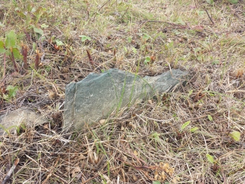
One of the unmarked rough stones, marking a grave, in situ.
Surface Survey
In actuality, we weren’t sure how many burials survived at the site when we arrived. The site’s location on a raised area within the landscape overlooking the water is congruent with characteristics of early burial grounds on the Avalon Peninsula (Pocius 1986, Lacy 2017). However, Ground Penetrating Radar (GPR) survey was carried out to attempt to identify burials before excavation could begin, to see if we could confirm the site prior to ground-truthing. An area was cleared in a 13 x 13m grid in order to conduct the survey (Grimes et al 2018). On the surface were some depressions that would be considered typical in any historical cemetery, but many did not line up with the assumed markers. The GPR results, along with detecting many anomalies that proved to be stones or roots, produced some results which were later identified as burials (Grimes et al 2018:133-134).
There were a large number of short, locally sourced stones sticking out of the grass. Most of the stones appeared to have been shaped into rough ‘gravestone’ like rectangles, and placed purposefully within the landscape. Some of these stones appeared to be in semi-organized rows, so all of them were treated as grave markers, and were catalogued and mapped using a total station theodolite (total station, or TST, depending on who you talk to). Rather than using traditional paper mapping techniques and digitizing it later, we did everything digitally to start with, and it saved so much time, while really allowing us to get a feel for the space in a form that could be manipulated on the computer at the end of the every day.

This gravestone fragment is made from imported English limestone.
Excavation
Once the stones that were laying on the surface were removed, it was time to carefully start excavating and see what was going on below the surface. With historic burial depths not being something that was standardized at all (Riordan 2000), it was likely we would be digging at least a meter down across the site, if not further.
The sediment was very compact and rocky in layers, but areas where a grave had been dug were much softer. This is a result of the soil having been dug up and many of the offending rocks having been removed during the digging of the grave shaft itself. The sediment in a grave is therefore a mixture of everything that was dug out, and filled back in, and usually has a different texture, compactness, and often colour than the surrounding sediment. This material is often much more organic than the surrounding sediment as well, due to the natural process of decomposition, especially the case when one excavates closer to the depth of the body itself.

Photo of fully excavated grave shafts, which no longer contain human remains. Note the varying shapes.
Before we could check for the preservation of human remains, however, the entire graveshaft had to be carefully excavated, checking for any potential artifacts or evidence of coffins. Going into this project, I suspected that it was likely that many of the individuals buried there would have had some sort of coffin, as the site dated to the 19th-century and coffins were very common by that point, even in rural Newfoundland. What we found was not only were the people being buried in wooden coffins, but that they used every single nail they could get their hands on to make said coffins. It was a very good thing that we were using a TST to record the site rather than mapping everything in by hand, or else this excavation would have taken a lot longer than a year (on and off, we were only there one or two days a week ish)! Pin-flags were used to mark features that were then mapped in using the TST; the edges of the grave shafts, the location of nails, surviving coffin wood, and human remains.
The preservation of the coffins themselves was very poor. While Newfoundland is renowned for its damp climate (and soils), wood has to remain completely waterlogged in order to be better preserved against rot and decomposition into the soil. However, we did manage to recover some pieces of wood from the bottom of a few of the coffins. In all of these cases, the wood was preserved underneath where the body’s torso or legs had been, or has been fused with rust from iron nails. In a few cases, the walls of the coffin itself were completed decomposed into the soil, but the soil stain created as a result was a perfect outline and provided not only shape but depth of the coffin itself. This was exciting because none of the coffin lids survived, but mapping with the TST allows us to recreate the size and shape of the coffins with these surviving details. This information will be useful for future research into C19th burial practices in Newfoundland.

Soil staining from the decomposed coffin wood left a perfect outline of the coffin itself.
It was very interesting to see that the majority of the burials uncovered have coffins that are considered a stereotypical ‘coffin’ shape. Some of the juvenile burials contained rectangular boxes instead, but in all cases a larger amount of nails than would normally be thought of as necessary to hold a coffin together were used.
There weren’t many artifacts recovered during the course of the excavation. Below the bottom of one coffin, a small sherd of ceramic was uncovered, and in another a copper 1862 Nova Scotia halfpenny was found tucked under the mandible of the individual buried there. What we did recover a lot of were small copper pins around the head. While we called them ‘shroud pins’ in the field, these pins were likely used to hold a piece of fabric around the individual’s head, which would have help the jaw closed. This was usually indicated by one copper pin found at the top of the cranium, or one on either side of the cranium. In one or two cases, several pins were found around the head and below the mandible, suggesting that a face-covering had been held in place using copper pins as well. In all cases, the copper helped to preserve pieces of the decomposing bone, and in a few of the burials the only remains of the cranium were the pieces that had been stained by the copper.

One of the only intact copper pins from the site.
What I found most interesting about being part of this excavation was learning what happens to organic material (i.e. human remains) in this type of environment. While the burials weren’t extraordinarily old (mid-late 19th century, likely), there were no complete skeletons recovered, and in most cases almost all of the bones had deteriorated and returned to the earth. While excavating slowly through the grave shaft, it was easy to tell when you were close to a spot where there might be remains. Rather than a silty sediment, the sediment surrounding where the body had been was enriched with organic material and had become a clay. In several of the burials, the combination of the copper pin deterioration and clay covering the cranium preserved some hair fibres of the individual, the uncovering of which was one of the indicators that we had located the cranium.

Area outlined in the photo is comprised of clay, where this individual once lay.
When excavating a grave shaft, we work across the entire grave systematically, not digging down farther in one area than another to make sure that all of the remains are exposed at once, evenly. This gives us as archaeologists a better understanding of how the body was oriented, and can even let us know if they were wrapped in a shroud, had their limbs bound (this was common in historic burials), and what position their arms were placed in. It also allows us to make sure we know how many bones are present in the burial for the site records. While troweling across the grave shafts (we switch to wooden tools when we get near bones to prevent from scraping any of them), I noticed that the distal end of the coffin had a lot of the same organic clay that we were seeing around the torso and cranium. It didn’t take long to understand that this clay was basically a ‘shadow’ created from where the legs of the individual had decomposed in situ. It was a perfect example of a body returning to the earth, and something I did not expect to see.

Metal fibres still stuck in the clay. Lab analysis revealed they are likely gold plated silver wires!
For the most part it was difficult to tell much from the graves during the excavation, and much of the information gained will be through laboratory analysis and research prior to the reburial of the remains (see preliminary results in Grimes et al 2018). However, there was one individual who may have come from a more affluent family. They had more than three copper pins surrounding their head, and the only evidence of clothing that we found throughout the entire excavation. While I was working to clear some of the clay away from the mandible I found what I thought were roots from one of the small plants that had taken advantage of the organic-rich soil, so I was careful not to pull on them. (Pulling away roots can be devastating to remains, as they have often grown through or into the bones and pulling them can destroy the bone, much like pulling vines off a gravestone destroy the inscription.) After removing some of the clay, it became evident that this was not a clump of roots, but in fact a cluster of fine wires, that appeared to be made of silver or even gold. They were in a Y-shape at the neck of the individual, and were likely embroidered or woven metallic fibres in the neckline of whatever garment this person was buried in.
Another clue about one individual at the site came from located additional pieces of the limestone gravestone, which I showed a photo of earlier in this post. An additional 17 or so pieces were uncovered throughout the excavation, and I reassembled the gravestone back in the Archaeology Department with Maria. While the important parts were missing (of course), the stone was revealed to have belonged to ‘Bridget Greeley’, and was carved from imported limestone, as was typical in Newfoundland at the time (Pocius 1975, 1981). Through researching the ‘Returns of Deaths for the District of Harbour Grace 1892-1897’, MA student Duncan Williams identified that she had died of typhoid fever in 1896, and was buried in the churchyard. I suspect that this site pre-dated the church’s establishment in the area, due to its proximity to the water and not a religious structure, which could account for the lack of formal records for this, any many early sites like it. Duncan also identified the poem carved on her grave, the 3rd stanza from James Montgomery’s ‘Parted Friends’:

The Bridget Greeley Stone.
“There is a world above,
Where parting is unknown;
A whole eternity of love,
Formed for the good alone;
And faith beholds the dying here,
Translated to that glorious Sphere!”
I could go into a whole analysis of the scripts on this gravestone, but will leave that for another day!
Overall, this excavation was an amazing learning experience for me and everyone involved, but also for the historic and archaeological record in Newfoundland. In total, we identified 31 east-west oriented grave shafts, 18 of which contained skeletal human remains (Grimes et al 2018). As the first complete colonial settler burial ground to be excavated on the island, it will be exciting to see what these individuals will be able to teach us about life in 19th-century Newfoundland.
(All photos in this post were taken by the author. For further information on the excavation, see Grimes et al 2018, linked in the References below)
References:
Grimes, Vaughan, Maria Lear, Jessica Munkittrick, and Robyn S. Lacy.
2018. Excavation and preliminary analysis of a historical burial ground at Foxtrap-2 (CjAf-10), Foxtrap, Newfoundland. Provincial Archaeology Office Annual Review, 2017. Provincial Archaeology Office, Department of Tourism, Culture, Industry and Innovation, Government of Newfoundland and Labrador. Available online at: https://www.gov.nl.ca/tcar/files/Vol-16-2017.pdf
Lacy, Robyn S.
2017. Here lieth interr’d: An examination of 17th-century British burial landscapes in eastern North America. Master of Arts thesis. Department of Archaeology: Memorial University of Newfoundland.
Pocius, Gerald L.
1975. The Place of Burial: Spatial focus of Contact in the Living with the Dead in Eastern Areas of the Avalon Peninsula of Newfoundland. Master of Arts thesis. Department of Folklore: Memorial University of Newfoundland.
Pocius, Gerald L.
1981. Eighteenth- and Nineteenth-century Newfoundland Gravestones: Self-sufficiency, Economic Specialization, and the Creation of Artifacts. Material Cultural Review. Volume 12 (Spring). Pp. 1-16.
Pocius, Gerald L.
1986. The Transformation of the Traditional Newfoundland Cemetery: Institutionalizing the Secular Dead. Material Culture REview, Volume 23, Spring 1986.
Riordan, Timothy B.
2000. Dig a Grave both Wide and Deep: An archaeological Investigation of Mortuary Practices in the 17th-Century Cemetery at St. Mary’s City, Maryland. St. Mary’s City Archaeological Series No. 3. Historic St. Mary’s City, Maryland.

Pingback: Death on the Screen: Taboo, Ep. 1, & 19th Century Burials | Spade & the Grave
August 10, 2022 at 5:06 pm
This kind of digging just fascinates me. A couple times my team came across old tools, but probably only 100 years old. Still really cool tho!
LikeLike
Pingback: Archaeology of Coffins & Shrouds in Colonial North America – Grave Matters